Flow
Flow
TriniTuner.com  |  Latest Event:  

Forums

The official tropical weather thread 2017

this is how we do it.......

Moderator: 3ne2nr Mods
User avatar
Duane 3NE 2NR
Admin
Posts: 28738
Joined: March 24th, 2003, 10:27 am
Location: T&T
Contact:

Re: The official tropical weather thread 2017

Postby Duane 3NE 2NR » June 16th, 2017, 8:23 pm

92L may threaten the Windward Islands

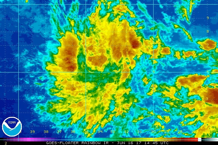
The NOAA/NWS National Hurricane Center (NHC) designated the central Atlantic wave as Invest 92L on Friday morning, which kicks off the process of tracking and forecasting this wave in greater detail. The wave was located at 8 am EDT Friday near 5°N 33°W, a few hundred miles southwest of the Cabo Verde Islands. Satellite imagery on Friday morning showed that Invest 92L was more organized than on Thursday, with a concentrated area of heavy thunderstorms developing near its core, and a modest amount of upper-level outflow becoming established.

The storm is too close to the equator for the system to leverage Earth's spin to help itself get spinning, which will make development slow to occur. Otherwise, conditions are favorable for development: the SHIPS model predicts that wind shear should remain light to moderate, dry air is expected to stay just to the north, and SSTs of 27-28°C (81-82°F) will be about 0.5°C above the seasonal norm along the wave’s track. In their 8 am EDT Friday Tropical Weather Outlook, the National Hurricane Center (NHC) gave this system 2-day and 5-day odds of tropical cyclone development (at least depression strength) of 20% and 40%, respectively—double the odds given on Thursday.

Image
Enhanced infrared satellite image of Invest 92L over the central tropical Atlantic as of 1445Z (10:45 am EDT) Friday, June 16, 2017. Image credit: NOAA/NESDIS.

Of our three top models for predicting tropical cyclone genesis, the European, GFS and UKMET models, only one--the GFS model--predicted in its 0Z Friday run that 92L would develop into a tropical depression over the next four days. Less than 10% of the European ensemble members produce a depression, while about two-thirds of the GFS ensemble members gin up 92L to depression strength, and roughly half bring it to tropical storm strength.

92L_tracks_latest.png


The 0Z Friday models had 92L maintaining a due west to slightly west-northwest track at 15 – 20 mph for the next five days, which would bring the system to the northern coast of Venezuela and into the Southern Lesser Antilles (Windward Islands) on Tuesday morning. The GFS track is slightly north of the ECMWF track, implying a higher chance of potential impacts to the islands of Trinidad and/or Grenada. The 06Z and 12Z Friday runs of the GFS brings the center near Trinidad as a mid-range tropical storm. Only one tropical storm and one hurricane have affected the Windwards or Venezuela prior to July 1 in NHC records going back to 1851.

Even if it becomes a named storm before reaching the Windwards, 92L is very unlikely to make it through the Caribbean Sea. The eastern Caribbean is a notorious “graveyard” for tropical cyclones, especially early in the season, because of persistent divergence at low levels that tends to weaken showers and thunderstorms. This divergence is the result of trade winds that are typically stronger in the central Caribbean than in the eastern Caribbean. None of the GFS and ECMWF ensemble members keep 92L as an identifiable system beyond the central Caribbean.

Source: https://www.wunderground.com/cat6/two-n ... g-atlantic

eekipoo
Sweet on this forum
Posts: 377
Joined: December 6th, 2005, 4:40 pm
Location: Nowhere

Re: The official tropical weather thread 2017

Postby eekipoo » June 16th, 2017, 9:14 pm

Ok this update is interesting..seems like we might get some heavy showers but not a storm based on NHC we'll see

matr1x
TriniTuner 24-7
Posts: 8222
Joined: February 25th, 2017, 7:46 am

Re: The official tropical weather thread 2017

Postby matr1x » June 16th, 2017, 9:33 pm

Perhaps
Attachments
two_atl_5d1-1.png

redmanjp
TriniTuner 24-7
Posts: 17670
Joined: September 22nd, 2009, 11:01 pm
Contact:

Re: The official tropical weather thread 2017

Postby redmanjp » June 17th, 2017, 2:14 am

Omg the next named storm is Bret. Allyuh remember Tropical Storm Bret in 1993 that was also in a Southern position? It went straight through or between T&T :shock:
Last edited by redmanjp on June 17th, 2017, 3:51 pm, edited 2 times in total.

matr1x
TriniTuner 24-7
Posts: 8222
Joined: February 25th, 2017, 7:46 am

Re: The official tropical weather thread 2017

Postby matr1x » June 17th, 2017, 5:43 am

You gotta be kidding me.
Attachments
two_atl_5d0-6.png

User avatar
shake d livin wake d dead
TunerGod
Posts: 33205
Joined: July 20th, 2009, 1:25 pm
Location: all over

Re: The official tropical weather thread 2017

Postby shake d livin wake d dead » June 17th, 2017, 6:32 am

Let's see if God is really a Trini....as we all say

eekipoo
Sweet on this forum
Posts: 377
Joined: December 6th, 2005, 4:40 pm
Location: Nowhere

Re: The official tropical weather thread 2017

Postby eekipoo » June 17th, 2017, 7:20 am

I still say IF it reach T.S strenght before it reach us from the time it start to spin it would head north..not saying we would get a complete miss but more of a graze tobago might get the bigger impact..#my2cents

Sent from my HUAWEI VNS-L23 using TriniTuner mobile app

matr1x
TriniTuner 24-7
Posts: 8222
Joined: February 25th, 2017, 7:46 am

Re: The official tropical weather thread 2017

Postby matr1x » June 17th, 2017, 7:54 am

Got off the line with 2 ppl from hurricane monitoring in Huston. Here is the breakdown :

There is a line of shear which if the system veers north will tear it apart, and it good for us. However there are 2 high pressure zones north which keeping it at 10 degrees north which is very very bad. These high pressure zones push it versus allowing it to veer north.

It's also passing over very warm water which is like pouring gallons of kerosene onto a bonfire.

Predicted path over Trinidad is currently 73 percent.

Also spoke to an astronomer in Trinidad observing Saturn opposition last night and he noted very little wind shear turbulence. Which is not good since Saturn looked perfect, but it means no shear to disrupt the system

matr1x
TriniTuner 24-7
Posts: 8222
Joined: February 25th, 2017, 7:46 am

Re: The official tropical weather thread 2017

Postby matr1x » June 17th, 2017, 7:58 am

Well crap
Attachments
two_atl_5d0-7.png

SRASC
3NE 2NR Moderator
Posts: 3272
Joined: January 13th, 2008, 10:53 am

Re: The official tropical weather thread 2017

Postby SRASC » June 17th, 2017, 8:01 am

Image

User avatar
MrSennin
Sweet on this forum
Posts: 348
Joined: December 5th, 2016, 6:10 am

Re: The official tropical weather thread 2017

Postby MrSennin » June 17th, 2017, 8:01 am

Rain in we m.......

matr1x
TriniTuner 24-7
Posts: 8222
Joined: February 25th, 2017, 7:46 am

Re: The official tropical weather thread 2017

Postby matr1x » June 17th, 2017, 8:08 am

I am less concerned about rain. It's wind that worries me. Remember how nasty trinity are with all we rubbish? Imagine those as projectiles

eekipoo
Sweet on this forum
Posts: 377
Joined: December 6th, 2005, 4:40 pm
Location: Nowhere

Re: The official tropical weather thread 2017

Postby eekipoo » June 17th, 2017, 8:30 am

matr1x wrote:I am less concerned about rain. It's wind that worries me. Remember how nasty trinity are with all we rubbish? Imagine those as projectiles

When is it forcasted to make landfall over trinidad?

Sent from my HUAWEI VNS-L23 using TriniTuner mobile app

matr1x
TriniTuner 24-7
Posts: 8222
Joined: February 25th, 2017, 7:46 am

Re: The official tropical weather thread 2017

Postby matr1x » June 17th, 2017, 9:17 am

Was sunday, but slowing down puts it at Monday to Monday night. There is a percentage possibly of miss..but at the given latitude is tough to pinpoint

bluefete
TriniTuner 24-7
Posts: 14659
Joined: November 12th, 2008, 10:56 pm
Location: POS

Re: The official tropical weather thread 2017

Postby bluefete » June 17th, 2017, 9:32 am

So when will the Met Service tell us to batten down the hatches? After it passes?

Better to tell us early and have it miss than tell us late and get hit.

People living Caroni and t'ing haffa buy boat an pirogue or move to Brian Lara. Dey need time to source funds and to prepare.

eekipoo
Sweet on this forum
Posts: 377
Joined: December 6th, 2005, 4:40 pm
Location: Nowhere

Re: The official tropical weather thread 2017

Postby eekipoo » June 17th, 2017, 10:03 am

bluefete wrote:So when will the Met Service tell us to batten down the hatches? After it passes?

Better to tell us early and have it miss than tell us late and get hit.

People living Caroni and t'ing haffa buy boat an pirogue or move to Brian Lara. Dey need time to source funds and to prepare.

Usually the case...like the press release the sent yesterday after the rain already beat down yuh roof

Sent from my HUAWEI VNS-L23 using TriniTuner mobile app

shotta 20
punchin NOS
Posts: 2799
Joined: January 9th, 2006, 4:15 pm
Contact:

Re: The official tropical weather thread 2017

Postby shotta 20 » June 17th, 2017, 10:09 am

^^^ x10000

User avatar
bluesclues
punchin NOS
Posts: 3600
Joined: December 5th, 2013, 3:35 am

Re: The official tropical weather thread 2017

Postby bluesclues » June 17th, 2017, 10:14 am

bluefete wrote:So when will the Met Service tell us to batten down the hatches? After it passes?

Better to tell us early and have it miss than tell us late and get hit.

People living Caroni and t'ing haffa buy boat an pirogue or move to Brian Lara. Dey need time to source funds and to prepare.

All now so, they supposed to have cpep on a rampage cleaning and clearing drains of debris to allow water to flow more freely especially in flood prone areas.

bluefete
TriniTuner 24-7
Posts: 14659
Joined: November 12th, 2008, 10:56 pm
Location: POS

Re: The official tropical weather thread 2017

Postby bluefete » June 17th, 2017, 10:48 am

bluesclues wrote:
bluefete wrote:So when will the Met Service tell us to batten down the hatches? After it passes?

Better to tell us early and have it miss than tell us late and get hit.

People living Caroni and t'ing haffa buy boat an pirogue or move to Brian Lara. Dey need time to source funds and to prepare.

All now so, they supposed to have cpep on a rampage cleaning and clearing drains of debris to allow water to flow more freely especially in flood prone areas.


Agreed.

Allyuh even think the government has any idea?

So what about ODPM? They not supposed to be mobilising all now as well? Just in case.

This would be a good test scenario.

Redman
TriniTuner 24-7
Posts: 10430
Joined: August 19th, 2004, 2:48 pm

Re: The official tropical weather thread 2017

Postby Redman » June 17th, 2017, 11:14 am

bluesclues wrote:
bluefete wrote:So when will the Met Service tell us to batten down the hatches? After it passes?

Better to tell us early and have it miss than tell us late and get hit.

People living Caroni and t'ing haffa buy boat an pirogue or move to Brian Lara. Dey need time to source funds and to prepare.

All now so, they supposed to have cpep on a rampage cleaning and clearing drains of debris to allow water to flow more freely especially in flood prone areas.


Dat SUPPOSED to be the dry season plan.

This year surprisingly the rainy season started around June....who would have thought?

User avatar
Duane 3NE 2NR
Admin
Posts: 28738
Joined: March 24th, 2003, 10:27 am
Location: T&T
Contact:

The official tropical weather thread 2017

Postby Duane 3NE 2NR » June 17th, 2017, 11:16 am

Aye issa long weekend. They might worry about it Tuesday morning.

We had moderate rain yesterday and there was chance of flooding. I don't think we can handle a tropical storm.

If it's any consolation, the system isn't even a tropical depression yet.

User avatar
bluesclues
punchin NOS
Posts: 3600
Joined: December 5th, 2013, 3:35 am

Re: The official tropical weather thread 2017

Postby bluesclues » June 17th, 2017, 11:54 am

Redman wrote:
bluesclues wrote:
bluefete wrote:So when will the Met Service tell us to batten down the hatches? After it passes?

Better to tell us early and have it miss than tell us late and get hit.

People living Caroni and t'ing haffa buy boat an pirogue or move to Brian Lara. Dey need time to source funds and to prepare.

All now so, they supposed to have cpep on a rampage cleaning and clearing drains of debris to allow water to flow more freely especially in flood prone areas.


Dat SUPPOSED to be the dry season plan.

This year surprisingly the rainy season started around June....who would have thought?


The patterns have been changing. But if we know a storm coming, we should be doing a pre-prep again in the days before.

User avatar
PariaMan
punchin NOS
Posts: 3742
Joined: July 9th, 2010, 10:38 am

Re: The official tropical weather thread 2017

Postby PariaMan » June 17th, 2017, 12:33 pm

The thing is just bad weather right now . What's the sense in creating confusion so early?

randolphinshan
Riding on 17's
Posts: 1362
Joined: November 20th, 2013, 12:08 pm

Re: The official tropical weather thread 2017

Postby randolphinshan » June 17th, 2017, 1:19 pm

PariaMan wrote:The thing is just bad weather right now . What's the sense in creating confusion so early?


^^^^
Exactly. Finally someone with some intelligence in here. Calm the fcuk out dudes..there is no need to start sucking each other's c#ck yet. Is just rain at the moment.

bluefete
TriniTuner 24-7
Posts: 14659
Joined: November 12th, 2008, 10:56 pm
Location: POS

Re: The official tropical weather thread 2017

Postby bluefete » June 17th, 2017, 1:20 pm

Duane 3NE 2NR wrote:Aye issa long weekend. They might worry about it Tuesday morning. :lol: :lol: :lol:

We had moderate rain yesterday and there was chance of flooding. I don't think we can handle a tropical storm. [b]When last did we handle a tropical storm.? Tobago got some terrible glancing blows a few years ago. This is not 1963 with Flora. [/b]

If it's any consolation, the system isn't even a tropical depression yet. It might be another case of God being a Trini. We will see in time.

User avatar
bluesclues
punchin NOS
Posts: 3600
Joined: December 5th, 2013, 3:35 am

Re: Re: The official tropical weather thread 2017

Postby bluesclues » June 17th, 2017, 2:07 pm

randolphinshan wrote:
PariaMan wrote:The thing is just bad weather right now . What's the sense in creating confusion so early?


^^^^
Exactly. Finally someone with some intelligence in here. Calm the fcuk out dudes..there is no need to start sucking each other's c#ck yet. Is just rain at the moment.


The way i see it. Whether or not the storm pass thru is no reason to start sucking eachother's c#ck.

bluefete
TriniTuner 24-7
Posts: 14659
Joined: November 12th, 2008, 10:56 pm
Location: POS

Re: The official tropical weather thread 2017

Postby bluefete » June 17th, 2017, 3:05 pm

https://www.facebook.com/notes/jm-netwo ... 252173884/


Hurricane Hunter Aircraft schedules flight into Disturbance east of Trinidad tomorrow.
JM Network·Saturday, June 17, 2017


During the last several days, The NATIONAL HURRICANE CENTER in Miami has been monitoring A Tropical WAVE about 3000km east, southeast of Trinidad.

In the latest update at 8am today, the National Hurricane Center said " A tropical wave located about 1500 miles east-southeast of the southern Windward Islands is producing scattered showers and thunderstorms. This disturbance has changed little in organization since yesterday.

However, some development is expected during the
next few days before conditions become less favorable for tropical cyclone formation. This system is expected to continue moving toward the west or west-northwest at 15 to 20 mph over the tropical Atlantic during the next several days.

* Formation chance through 48 hours...medium...40 percent.

* Formation chance through 5 days...high...70 percent."

Tomorrow, Sunday 18th June, 2017, The Hurricane Hunter aircraft has scheduled a flight mission into the system at 4pm Local time.

They normally go into TROPICAL DISTURBANCES that have the potential to develop into Tropical Cyclones and cause dangerous weather conditions to land.

This hands on observation will assist the Meteorological Experts at the office in determining various information that may be difficult to receive on ground.


000
NOUS42 KNHC 171631
REPRPD
WEATHER RECONNAISSANCE FLIGHTS
CARCAH, NATIONAL HURRICANE CENTER, MIAMI, FL.
1230 PM EDT SAT 17 JUNE 2017
SUBJECT: TROPICAL CYCLONE PLAN OF THE DAY (TCPOD)
VALID 18/1100Z TO 19/1100Z JUNE 2017
TCPOD NUMBER.....17-017

I. ATLANTIC REQUIREMENTS
1. SUSPECT AREA (NW CARIBBEAN)
FLIGHT ONE -- TEAL 71 FLIGHT TWO -- TEAL 72
A. 18/2000Z A. 19/1130Z,1730Z
B. AFXXX 01AAA INVEST B. AFXXX 0202A CYCLONE
C. 18/1730Z C. 19/0945Z
D. 20.0N 86.5W D. 22.0N 87.5W
E. 18/1930Z TO 18/2330Z E. 19/1100Z TO 19/1730Z
F. SFC TO 10,000 FT F. SFC TO 10,000 FT

2. OUTLOOK FOR SUCCEEDING DAY:
A. CONTINUE 6-HRLY FIXES IF ABOVE SYSTEM DEVELOPS AND REMAINS
A THREAT.
B. POSSIBLE LOW-LEVEL INVEST MISSION OVER CENTRAL ATLANTIC EAST
OF TRINIDAD NEAR 9.5N 58.0W FOR 19/1800Z.

wx_klb
Street 2NR
Posts: 34
Joined: August 2nd, 2015, 9:43 pm

Re: The official tropical weather thread 2017

Postby wx_klb » June 17th, 2017, 3:13 pm

This Hurricane Hunter Flight is for the system near the Yucatan, not the one east of Trinidad.

bluefete wrote:https://www.facebook.com/notes/jm-network/hurricane-hunter-aircraft-schedules-flight-into-disturbance-east-of-trinidad-tom/1445581252173884/


Hurricane Hunter Aircraft schedules flight into Disturbance east of Trinidad tomorrow.
JM Network·Saturday, June 17, 2017


During the last several days, The NATIONAL HURRICANE CENTER in Miami has been monitoring A Tropical WAVE about 3000km east, southeast of Trinidad.

In the latest update at 8am today, the National Hurricane Center said " A tropical wave located about 1500 miles east-southeast of the southern Windward Islands is producing scattered showers and thunderstorms. This disturbance has changed little in organization since yesterday.

However, some development is expected during the
next few days before conditions become less favorable for tropical cyclone formation. This system is expected to continue moving toward the west or west-northwest at 15 to 20 mph over the tropical Atlantic during the next several days.

* Formation chance through 48 hours...medium...40 percent.

* Formation chance through 5 days...high...70 percent."

Tomorrow, Sunday 18th June, 2017, The Hurricane Hunter aircraft has scheduled a flight mission into the system at 4pm Local time.

They normally go into TROPICAL DISTURBANCES that have the potential to develop into Tropical Cyclones and cause dangerous weather conditions to land.

This hands on observation will assist the Meteorological Experts at the office in determining various information that may be difficult to receive on ground.


000
NOUS42 KNHC 171631
REPRPD
WEATHER RECONNAISSANCE FLIGHTS
CARCAH, NATIONAL HURRICANE CENTER, MIAMI, FL.
1230 PM EDT SAT 17 JUNE 2017
SUBJECT: TROPICAL CYCLONE PLAN OF THE DAY (TCPOD)
VALID 18/1100Z TO 19/1100Z JUNE 2017
TCPOD NUMBER.....17-017

I. ATLANTIC REQUIREMENTS
1. SUSPECT AREA (NW CARIBBEAN)
FLIGHT ONE -- TEAL 71 FLIGHT TWO -- TEAL 72
A. 18/2000Z A. 19/1130Z,1730Z
B. AFXXX 01AAA INVEST B. AFXXX 0202A CYCLONE
C. 18/1730Z C. 19/0945Z
D. 20.0N 86.5W D. 22.0N 87.5W
E. 18/1930Z TO 18/2330Z E. 19/1100Z TO 19/1730Z
F. SFC TO 10,000 FT F. SFC TO 10,000 FT

2. OUTLOOK FOR SUCCEEDING DAY:
A. CONTINUE 6-HRLY FIXES IF ABOVE SYSTEM DEVELOPS AND REMAINS
A THREAT.
B. POSSIBLE LOW-LEVEL INVEST MISSION OVER CENTRAL ATLANTIC EAST
OF TRINIDAD NEAR 9.5N 58.0W FOR 19/1800Z.

User avatar
agent007
punchin NOS
Posts: 2774
Joined: November 19th, 2008, 11:19 am

Re: The official tropical weather thread 2017

Postby agent007 » June 17th, 2017, 3:27 pm

Guys if the system develops could it be TD Cindy? I'm asking because the one in the GOM seems to be more like TD Bret. I just hope this thing passes by and spares us. The soil is too saturated ATM to take more jammin from a storm system right now.

bluefete
TriniTuner 24-7
Posts: 14659
Joined: November 12th, 2008, 10:56 pm
Location: POS

Re: The official tropical weather thread 2017

Postby bluefete » June 17th, 2017, 3:36 pm

Hurricane Hunter Aircraft schedules flight into Disturbance east of Trinidad tomorrow.

wx_klb wrote:This Hurricane Hunter Flight is for the system near the Yucatan, not the one east of Trinidad. ]


Image

East of Trinidad ---->>>>>>>>>>>>>>>>>>>>>>>>>>>>>>>>>>>

West of Trinidad ---<<<<<<<<<<<<<<<<<<<<<<<<<<<<<<<<<<

Get it???
Last edited by bluefete on June 17th, 2017, 4:56 pm, edited 1 time in total.

Advertisement

Return to “Ole talk and more Ole talk”

Who is online

Users browsing this forum: pugboy and 16 guests