TriniTuner.com | Latest Event:


Moderator: 3ne2nr Mods


matr1x wrote:I am less concerned about rain. It's wind that worries me. Remember how nasty trinity are with all we rubbish? Imagine those as projectiles
bluefete wrote:So when will the Met Service tell us to batten down the hatches? After it passes?
Better to tell us early and have it miss than tell us late and get hit.
People living Caroni and t'ing haffa buy boat an pirogue or move to Brian Lara. Dey need time to source funds and to prepare.

bluefete wrote:So when will the Met Service tell us to batten down the hatches? After it passes?
Better to tell us early and have it miss than tell us late and get hit.
People living Caroni and t'ing haffa buy boat an pirogue or move to Brian Lara. Dey need time to source funds and to prepare.
bluesclues wrote:bluefete wrote:So when will the Met Service tell us to batten down the hatches? After it passes?
Better to tell us early and have it miss than tell us late and get hit.
People living Caroni and t'ing haffa buy boat an pirogue or move to Brian Lara. Dey need time to source funds and to prepare.
All now so, they supposed to have cpep on a rampage cleaning and clearing drains of debris to allow water to flow more freely especially in flood prone areas.
Redman wrote:bluesclues wrote:bluefete wrote:So when will the Met Service tell us to batten down the hatches? After it passes?
Better to tell us early and have it miss than tell us late and get hit.
People living Caroni and t'ing haffa buy boat an pirogue or move to Brian Lara. Dey need time to source funds and to prepare.
All now so, they supposed to have cpep on a rampage cleaning and clearing drains of debris to allow water to flow more freely especially in flood prone areas.
Dat SUPPOSED to be the dry season plan.
This year surprisingly the rainy season started around June....who would have thought?
PariaMan wrote:The thing is just bad weather right now . What's the sense in creating confusion so early?
Duane 3NE 2NR wrote:Aye issa long weekend. They might worry about it Tuesday morning.
We had moderate rain yesterday and there was chance of flooding. I don't think we can handle a tropical storm. [b]When last did we handle a tropical storm.? Tobago got some terrible glancing blows a few years ago. This is not 1963 with Flora. [/b]
If it's any consolation, the system isn't even a tropical depression yet. It might be another case of God being a Trini. We will see in time.
randolphinshan wrote:PariaMan wrote:The thing is just bad weather right now . What's the sense in creating confusion so early?
^^^^
Exactly. Finally someone with some intelligence in here. Calm the fcuk out dudes..there is no need to start sucking each other's c#ck yet. Is just rain at the moment.
bluefete wrote:https://www.facebook.com/notes/jm-network/hurricane-hunter-aircraft-schedules-flight-into-disturbance-east-of-trinidad-tom/1445581252173884/
Hurricane Hunter Aircraft schedules flight into Disturbance east of Trinidad tomorrow.
JM Network·Saturday, June 17, 2017
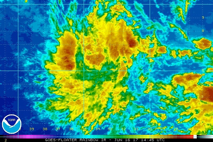
During the last several days, The NATIONAL HURRICANE CENTER in Miami has been monitoring A Tropical WAVE about 3000km east, southeast of Trinidad.
In the latest update at 8am today, the National Hurricane Center said " A tropical wave located about 1500 miles east-southeast of the southern Windward Islands is producing scattered showers and thunderstorms. This disturbance has changed little in organization since yesterday.
However, some development is expected during the
next few days before conditions become less favorable for tropical cyclone formation. This system is expected to continue moving toward the west or west-northwest at 15 to 20 mph over the tropical Atlantic during the next several days.
* Formation chance through 48 hours...medium...40 percent.
* Formation chance through 5 days...high...70 percent."
Tomorrow, Sunday 18th June, 2017, The Hurricane Hunter aircraft has scheduled a flight mission into the system at 4pm Local time.
They normally go into TROPICAL DISTURBANCES that have the potential to develop into Tropical Cyclones and cause dangerous weather conditions to land.
This hands on observation will assist the Meteorological Experts at the office in determining various information that may be difficult to receive on ground.
000
NOUS42 KNHC 171631
REPRPD
WEATHER RECONNAISSANCE FLIGHTS
CARCAH, NATIONAL HURRICANE CENTER, MIAMI, FL.
1230 PM EDT SAT 17 JUNE 2017
SUBJECT: TROPICAL CYCLONE PLAN OF THE DAY (TCPOD)
VALID 18/1100Z TO 19/1100Z JUNE 2017
TCPOD NUMBER.....17-017
I. ATLANTIC REQUIREMENTS
1. SUSPECT AREA (NW CARIBBEAN)
FLIGHT ONE -- TEAL 71 FLIGHT TWO -- TEAL 72
A. 18/2000Z A. 19/1130Z,1730Z
B. AFXXX 01AAA INVEST B. AFXXX 0202A CYCLONE
C. 18/1730Z C. 19/0945Z
D. 20.0N 86.5W D. 22.0N 87.5W
E. 18/1930Z TO 18/2330Z E. 19/1100Z TO 19/1730Z
F. SFC TO 10,000 FT F. SFC TO 10,000 FT
2. OUTLOOK FOR SUCCEEDING DAY:
A. CONTINUE 6-HRLY FIXES IF ABOVE SYSTEM DEVELOPS AND REMAINS
A THREAT.
B. POSSIBLE LOW-LEVEL INVEST MISSION OVER CENTRAL ATLANTIC EAST
OF TRINIDAD NEAR 9.5N 58.0W FOR 19/1800Z.
wx_klb wrote:This Hurricane Hunter Flight is for the system near the Yucatan, not the one east of Trinidad. ]

Return to “Ole talk and more Ole talk”
Users browsing this forum: Bing [Bot], Google Adsense [Bot], ProtonPowder and 13 guests


