TriniTuner.com | Latest Event:


Moderator: 3ne2nr Mods


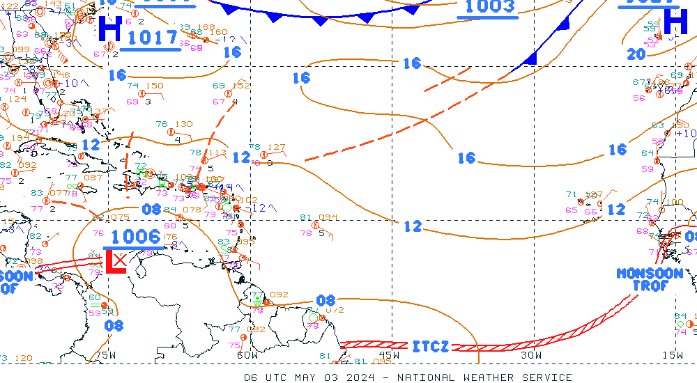
JoKeR1980 wrote:Hook wrote:I'm a little drunk. Here's an information bulletin Met issued this morning.
My apologies for not posting it differently.
Visit http://www.metoffice.gov.tt for more info.
and you need us now?


THE ATLANTIC OCEAN...
AN UPPER LEVEL RIDGE OVER THE EASTERN GULF OF MEXICO POURS OVER
INTO THE WEST ATLC SUPPORTING A 1023 MB HIGH NEAR 30N77W...WHICH
IS PROVIDING MOSTLY FAIR CONDITIONS ACROSS THE WEST ATLC.
HOWEVER...A WEAK UPPER LEVEL LOW NEAR 25N76W SUPPORTS A SURFACE
TROUGH THAT EXTENDS INTO THE RIDGE ALONG 30N64W 29N68W 30N73W.
THE UPPER TROUGH IS EMBEDDED WITH DRY AIR...SO NO SHOWER
ACTIVITY IS NOTED NEAR THE SURFACE TROUGH. ACROSS THE CENTRAL
ATLC...A DEEP LAYERED LOW PRESSURE SYSTEM DOMINATES PROVIDING
SEVERAL ENERGY SURGES ACROSS THE AREA. FARTHEST EAST...A
STATIONARY FRONT ENTERS THE AREA NEAR 32N32W AND CONTINUES ALONG
24N38W 16N50W. SCATTERED SHOWERS/POSSIBLE THUNDERSTORMS ARE
WITHIN 200 NM WEST OF THE AXIS NORTH OF 25W. A SECOND SURGE IS
BRING ISOLATED SHOWERS NORTH OF 28N BETWEEN 44W-54W. GALE FORCE
WINDS ARE ALSO NOTED IN THE AREA NORTH OF 29N BETWEEN 50W-55W.
THE REMAINDER OF THE BASIN IS COVERED BY SURFACE RIDGING
EXTENDING FROM A 1033 MB HIGH WELL NORTH OF THE DISCUSSION AREA
NEAR 46N20W. THE RIDGE IS SUPPORTED BY AN UPPER LEVEL RIDGE
ALONG 24W.


Hook wrote:Yeah, it's SUPPOSED to be moving back a little more south by now though, but you see what the stationary front is doing to it.
From since Friday the L.L.E.W.M. (Low Level Easterly Wind Maximum...pronounced "loom") has been weakening so clouds will have less chance of shearing off before they get to the mid-levels, which means a higher possibility of build-ups.
If that trough south-east of us moves, we might get some showers and MAYBE a couple thundershowers on Wednesday, but I don't think it'll be super terrible given it's a 1012mb isobar, so it's not super low.
The official word on that should be in the 4-Day Weather Outlook that should be issued later today.

Hook wrote:The way admin installed the new satellite receiver, the generator and just now the A.W.O.S., It suggests that we're not going to see this new building for another 20yrs.


Return to “Ole talk and more Ole talk”
Users browsing this forum: No registered users and 20 guests