TriniTuner.com | Latest Event:


Moderator: 3ne2nr Mods

maj. tom wrote:Whoever that is must be put their thermometer directly in the sun in a closed box instead of a properly calibrated Stevenson screen. Reporting news like that is very irresponsible.

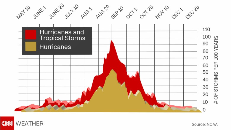
NWS National Hurricane Center Miami FL
800 AM EDT Thu Sep 12 2019
For the North Atlantic...Caribbean Sea and the Gulf of Mexico:
1. Satellite images indicate that the area of disturbed weather over
the central and southeastern Bahamas is gradually becoming better
organized while surface pressures are falling in the area.
Conditions are becoming favorable for a tropical depression or a
tropical storm to form within the next day or so as the system moves
toward the northwest through the northwestern Bahamas and toward
the Florida Peninsula at 5 to 10 mph. If this development trend
continues Potential Tropical Cyclone advisories will likely be
initiated later today. This disturbance will bring heavy rainfall
and gusty winds across portions of the Bahamas through Friday,
especially in portions of the northwestern Bahamas affected by
Hurricane Dorian. An Air Force Reserve reconnaissance aircraft is
scheduled to investigate the system this afternoon, if necessary.
* Formation chance through 48 hours...high...70 percent.
* Formation chance through 5 days...high...80 percent.


brickman wrote:The heat today was on a different level....
God wrote:Allyuh want to say I's one of you? Take heat from downstairs in yuh tail.

brickman wrote:*crosses fingers for some relief today*
Return to “Ole talk and more Ole talk”
Users browsing this forum: Google [Bot] and 58 guests