We are still not paying attention.
Friday into Saturday and Monday into Tuesday!
Atlantic Tropical Update: Tropical Wave to Move Across T&T on Friday, Bringing Showers & Thunderstorms
WEDNESDAY, 26 JUNE 2019, 15:56Tropical Weather Update:

— Tropical Wave 12: This wave is located just east of the Lesser Antilles. However, this wave is devoid of convection due to its location within a plume of Saharan Dust and a dry mid-level environment. Very little change in weather is forecast as this wave traverses the region on Thursday.
— Tropical Wave 13: This wave is located in the Central Atlantic, embedded within the ITCZ. The axis of this wave is forecast to move across Trinidad and Tobago on Friday, bringing the ITCZ closer to T&T as well. Cloudy skies, scattered to widespread showers and isolated thunderstorms, mainly across Trinidad, are in the forecast. Locally heavy rainfall and gusty winds are possible due to favorable atmospheric conditions forecast. Possible locally severe weather.
— Tropical Wave 14: A new tropical wave is moving off the African Coast with scattered moderate and isolated strong showers and thunderstorms occurring near the axis of the wave. This wave is forecast to move across T&T on Monday into Tuesday. Saharan Dust will limit showers and thunderstorms across T&T during this period.
— No Tropical Development forecast elsewhere across the Atlantic basin over the next 5 days as of the latest tropical update.
Tropical Wave 12
The axis of this wave is located along 53W from 02N-20N, moving west around 15 knots. Dry Saharan air surrounds the wave, limiting convection at this time. The wave is clearly identifiable from 700 millibar trough diagnostics as well as a surface trough seen in the ASCAT scatterometer observations.
This wave is not forecast to bring any notable change in the dry, dusty weather ahead of Tropical Wave 13. No impacts to Trinidad and Tobago forecast.
Tropical Wave 13

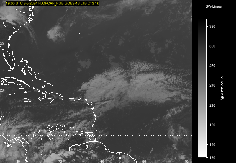
Tropical Wave 13 in the Central Atlantic, with scattered showers and isolated thunderstorms near the wave axis. This wave has a large moisture field, so showers and possible thunderstorms are in the forecast on Friday into early Saturday for T&T Image Credit: Weathernerds.org
This tropical wave’s axis extends along 38W, from 06N to 17N, moving west at 15 knots. Scattered moderate showers and isolated thunderstorms are noted from 05N-07N between 36W-40W. The position of the wave is mainly based upon a maximum in Total Precipitable Water east of the wave axis along with 700 millibar trough diagnostics. No significant surface signature is present with this wave.
This wave is forecast to move across T&T on Friday into the early hours of Saturday of next week, bringing increased cloudiness, scattered showers and possible thunderstorms, favoring Trinidad. The ITCZ may also pay another visit to the islands, beginning Thursday night, which may bring a heavy rainfall threat.
In addition, an upper level trough will be favorably positioned on Friday into Saturday. This is forecast to create favorable upper level divergence, aiding in the development and sustaining deep convection such as heavy showers and thunderstorms across the Southern Windwards, including Trinidad and Tobago.
As of this tropical update, this wave is not forecast to produce widespread severe weather.
However, isolated to scattered severe weather is possible as isolated to scattered heavy showers and thunderstorms are in the forecast as well as gusty winds. This potential severe weather is likely to begin by 2:00 AM Friday, through 8:00 AM Saturday.
Possible Impacts to Trinidad and TobagoLocally Heavy Rainfall & Flooding: Based on the 12Z Tuesday model runs, from Thursday night (8:00 PM) through Saturday morning (8:00 AM), generally less than 15 millimeters across Tobago, with locally heavier amounts along the Southern coast of the island or where thunderstorms/heavy showers occur.
Flood SafetyAcross Trinidad, heavy rainfall is likely across Eastern parts of the island, with rainfall totals generally between 20-40 millimeters, and isolated areas receiving up to 60 millimeters, as of the latest model guidance. Across Southern and Central Trinidad, generally, 20-40 millimeters of rainfall is also forecast. Western and Northwestern Trinidad may see the “lowest” totals, as expected with weaker tropical waves in June, with generally less than 20 millimeters of rainfall forecast over the 36 hour period, though isolated heavier totals are possible in the vicinity of thunderstorms or heavy showers.
The heaviest activity is forecast to occur on Friday. Generally, with heavy showers and thunderstorm activity, street flooding, particularly in flood-prone areas or areas with poor drainage, is possible as well as flash flooding in areas where more prolonged heavy rainfall may occur, based on the above-mentioned forecast rainfall totals.
Frequent Lightning: In addition, with thunderstorms, frequent lightning is likely. Thunderstorms are forecast to occur mainly after midnight Friday, through the early hours of Saturday, across T&T.
Gusty Winds: Gusty winds, generally between 50-60 KM/H are likely. Gusts up to 75 KM/H are possible across Eastern Tobago and higher elevations across the Northern Range, Trinidad, while peak gusts across the majority of Trinidad and Tobago of up to 70 KM/H may occur. Gusty winds are most likely during the latter half of Friday. These wind gusts will generally occur prior to, in the vicinity of, or occur during heavy showers or thunderstorms. With wind gusts up to 74 KM/H, whole trees are expected to be in motion and there may be some inconvenience when walking against the wind gusts. Light outdoor objects may topple or become airborne such as garbage cans, loose galvanize or construction material and other outdoor furniture. Tents may jump.