TriniTuner.com | Latest Event:


Moderator: 3ne2nr Mods


Situated in the heart of the city, Woodford Square is bordered by Frederick Street on the East, Abercromby Street on the West, Hart Street on the South and Knox Street on the North. It is surrounded by some very important buildings - Trinity Cathedral on its southern side; the Town Hall, Public Library and the Hall of Justice are on the northern side; the Greyfriars Presbyterian Church is on the eastern side; while the Red House is on the western side of the Square.
In the days when Port of Spain was just a little fishing village called Conquerabia, Woodford Square was first known as the Place of Souls by the native Indians who fought a bloody battle on this open space. The St Ann's River ran through this open space and down to the sea. The course of the river was later changed to what is today called The Dry River. The riverbed in the Place of Souls was filled up. With the coming of the French settlers to the island, they called the Place of souls - Place Des Ames. Place Des Ames means Place of souls.
Place Des Ames later became known as Brunswick Square. Brunswick Square was used as a parade ground for soldiers.
Many of these soldiers were Germans. Brunswick is a German name, and so it is believed that this open space was named after the German soldiers who used it.
* 1808 - Port of Spain is on fire. The fire burns all night.
Many buildings in Port of Spain are burnt to the ground. Many persons are homeless. Tents are put up in Brunswick Square. Rebuilding of the Anglican Church begins immediately but this time in the centre of the Square. People are angry. They complain to the Governor. Work on the church in the Square is stopped. The church is removed to the corner of Hart and Abercromby Streets where it stands today. That church is Trinity Cathedral.
* 1813 - Governor Sir Ralph Woodford arrives in Trinidad. He immediately begins rebuilding the town and lays out the square.
* 1866 - A fountain was put I the centre of the Square. The fountain was a gift from George Gregor Turnbull of Glasgow, Scotland.
* 1892 - New heavy railings were put up around the square. These are the ones we see today.
* 1917 - A bandstand was built and opened by Dr E. Prada, the then Mayor of Port of Spain. At the opening of the bandstand the name of the square was changed from Brunswick Square to Woodford Square in honour of the Governor Sir Ralph Woodford.
* 1948 - Paul Robeson the famous black American singer entertained crowds in Woodford Square.
* 1960 - Marion Anderson world famous black American singer performed in Woodford Square.
* 1969 - Winnifred Atwell a world famous Trinidadian pianist performed in Woodford Square.
Over the year, people have called Woodford Square by different names: 'The University of Woodford Square', 'The People's Parliament'.
* 1962 - The year of our country's Independence another fountain in the northeastern corner of the square was built. The spot is known as the meditation corner.
Woodford Square is not only an open space, where people gather to enjoy good entertainment. Woodford Square is an open space where people go to protest their conditions of living.
* 1903 - The then government plans to increase water rates. People are against it. While the council meets in the Red House, people gather in Woodford Square to protest.
* 1956 - A new political party - The Peoples' National Movement (PNM) under their political leader Dr. Eric Williams draws crowds to Woodford Square to hear him tell of his party's plan to make Trinidad and Tobago an independent nation. He gives Woodford Square the name The University of Woodford Square.
* 1970 - Many are without work. They are dissatisfied. They protest. Marches and demonstrations either start or end at Woodford Square.
* 1 History
* 2 Map and Locations
* 3 Important NPCs
* 4 Available Missions
* 5 Sources
[edit] History
Docks of Port-of-Spain
Both Trinidad and Tobago were originally settled by Amerindians of South American origin. Trinidad was first settled by pre-agricultural Archaic people at least 7,000 years ago, making it the earliest-settled part of the Caribbean. Ceramic-using agriculturalists settled Trinidad around 250 BCE and then moved further up the Lesser Antillean chain. At the time of European contact Trinidad was occupied by various Arawakan-speaking groups including the Nepoya and Suppoya, and Cariban-speaking groups such as the Yao, while Tobago was occupied by the Island Caribs and Galibi. The Amerindian name for Trinidad was Kairi or Iere which is usually translated as The Land of the Hummingbird, although others have reported that it simply meant island. Christopher Columbus encountered the island of Trinidad on July 31, 1498 and named it after the Holy Trinity. Columbus reported seeing Tobago, which he named Bella Forma, but did not land on the island. The name Tobago is probably derived from tobacco, although the English pronunciation is to-bay-go, rhyming with plumbago and sago.
Antonio de Sedeño first settled Trinidad in the 1530s as a means of controlling the Orinoco and subduing the Warao (Whitehead, 1997). Cacique Wannawanare (Guanaguanare) granted the St Joseph area to Domingo de Vera e Ibargüen in 1592 and then withdrew to another part of the island (Boomert, 2000). San José de Oruña (St Joseph) was established by Antonio de BerrÃo on this land. Walter Raleigh arrived in Trinedado on March 22 1595, casting anchor at Curiapan/Punta de Gallos and described the pitch lake (Piche or Tierra de Brea) and the Annaperima hill. This hill was known to the Warao as the home of the sea god Na’barima (Whitehead, 1997; 131). Raleigh soon attacked San José and captured and interrogated de BerrÃo obtaining much information from him and from the cacique Topiawari (Whitehead, 1997). In the 1700s, Trinidad belonged as an island province to the viceroyalty of New Spain along with modern Mexico and Central America (Besson, 2000). The Dutch and the Courlanders had established themselves in Tobago in the 16th and 17th centuries and produced tobacco and cotton. However Trinidad in this period was still mostly forest, populated by a few Spaniards with their handful of slaves and a few thousand Amerindians (Besson, 2000). Spanish colonisation in Trinidad remained tenuous. In 1762, after three hundred years of Spanish rule San José de Oruña and Puerto de España (Port of Spain) were hamlets rather than towns. Because Trinidad was considered underpopulated, Roume de St. Laurent, a Frenchman living in Grenada, was able to obtain a Cédula de Población from the Spanish King Charles III on the 4th November, 1783. This Cédula de Población was more generous than the first of 1776 and granted free lands to Roman Catholic foreign settlers and their slaves in Trinidad willing to swear allegiance to the Spanish king. The land grant was thirty two acres for each man, woman and child and half of that for each slave brought. As a result, Scots, Irish, German, Italian and English families arrived. The Protestants among them profited from Governor Don José Maria Chacon's generous interpretation of the law. The French Revolution (1789) also had an impact on Trinidad's culture since it resulted in the emigration of Martiniquan planters and their slaves to Trinidad who established an agriculture-based economy (sugar and cocoa) for the island (Besson, 2000).
Port of Spain was founded near the site of the Amerindian fishing village of Cumucurapo ("place of the silk cotton trees"), located in the area today known as Mucurapo, west of the city centre. The name Conquerabia is also recorded for an Amerindian settlement in this area; this may have been a separate village, another name for Cumucurapo, or the result of miscomprehension by early Spanish settlers, who established a port here: Puerto de los Hispanioles, later Puerto de España. In 1560, a Spanish garrison was posted near the foot of the Laventille Hills, which today form the city's eastern boundary.
The part of today's downtown Port of Spain closest to the sea was once an area of tidal mudflats covered by mangroves. The first Spanish buildings here, in the 16th and 17th centuries, were open mud-plastered ajoupas, interspersed between large silk cotton trees and other trees. The fort was a mud-walled enclosure with a shack inside, a flagpole, two or three cannon, and few Spanish soldiers. The Caribs were transient, travelling to the mainland (now Venezuela) and up the Orinoco River. The French naval commander Comte D'Estrées visited in 1680, and reported that there was no Port of Spain. But in 1690, Spanish governor Don Sebastien de Roteta reported in writing to the King of Spain: "Already six houses have been made and others have been started. There is already a church in this place, so that it was unnecessary to build a new."
In 1699, the alcalde of Trinidad reported to the King that the natives "were in the habit of showering scorn and abuse upon the Holy Faith and ridiculed with jests the efforts of the Holy Fathers".
By 1757, the old capital, San José de Oruña (modern Saint Joseph), about seven miles (11 km) inland, had fallen into disrepair, and Governor Don Pedro de la Moneda transferred his seat to Port of Spain, which thus became Trinidad's de facto capital. The last Spanish Governor of Trinidad, Don José Maria Chacón, devoted much of his time to developing the new capital. He compelled the island's Cabildo (governing council) to move to Port of Spain, and he limited its powers to the municipality. The 1783 Cedula of Population, which encouraged the settlement of French Catholics in the island, led to a rapid increase in the town's population and its geographical extension westwards.
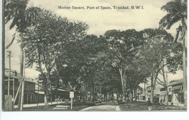
From the small cluster of buildings at the foot of the Laventille Hills, eleven streets were laid out west to the area bounded by the St. Ann's River, thus establishing the grid pattern which has survived in downtown Port of Spain to the present day. Along the sea shore was the Plaza del Marina (Marine Square), a parade ground. By 1786, the town had a population of about 3,000.
Realising that the St. Ann's River, prone to flooding, was impeding the expansion of the town, Chacón had its course diverted in 1787 so that it ran to the east of the city, along the foot of the Laventille Hills. (During the rainy season the river still had a tendency to overflow its banks, flooding parts of the city; over the decades its channel would be widened and paved. During the dry season the water level drops to a trickle; hence its nickname, the East Dry River.) Port of Spain was now able to continue spreading northwards and westwards, encroaching on the surrounding sugar-cane plantations.
In 1797, Trinidad was invaded by a British force under General Sir Ralph Abercromby. The British landed west of Port of Spain, at what is still called Invaders Bay, and marched towards the town. Realising his military resources were inadequate to defend the colony and wishing to avoid unnecessary destruction, Governor Chacón capitulated and was able to negotiate generous terms with Abercromby. Port of Spain remained the capital; the new British colonial government renamed most of the streets after British royalty or military figures, but allowed Chacón Street (which followed the old course of the St. Ann's River) to retain its name, in tribute to the former governor.
Duane 3NE 2NR wrote:hope this doesnt happen again....
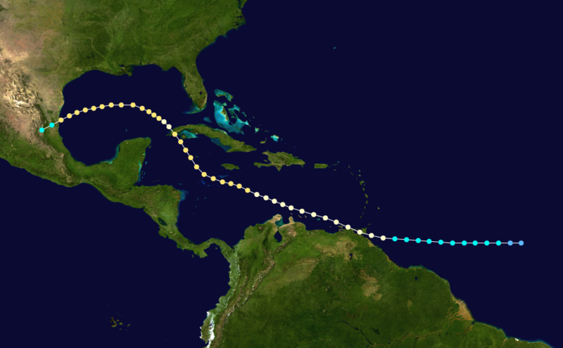
Because technologies such as satellite monitoring were not available until the 1960s, historical data on tropical cyclones from this period are often not reliable. But the 1933 Atlantic hurricane season was the second most active Atlantic hurricane season on record, with 21 known storms forming during that year in the northwest Atlantic Ocean. The season ran through the summer and the first half of fall in 1933, and was surpassed in total number of tropical cyclones by the 2005 season, which broke the record with its 28 storms.
in 1933
Storm number 2 was a Hurricane when it passed over T&T the hurricane caused severe damage, amounting to around US$3 million in 1933 USD or $50.4 million in 2010 USD. 13 people were killed on the island, and another 1,000 were left homeless.The hurricane season officially began on June 1st 1933, but there was little detectable activity during most of June. That tranquility came to an end on June 27, when a tropical storm was first observed just off the coast of northern Guyana. It strengthened as it moved west-northwestward, and it became a hurricane later that day. Continuing to the west-northwest, the hurricane "brushed" southern Trinidad and made landfall on northeastern Venezuela on June 28, becoming the earliest known tropical cyclone to affect the area. The system weakened to a tropical storm over land but re-attained hurricane status on July 1 while in the western Caribbean Sea. The hurricane curved to the northwest and moved over western Cuba on July 3. It turned to the west in the Gulf of Mexico and reached a peak intensity of 105 mph (170 km/h) on July 5, making it a Category 2 hurricane. The hurricane turned to the west-southwest due to a building high pressure area to its north then weakened. It made landfall on the coast of Tamaulipas and weakened to tropical storm status. The system finally dissipated over land on July 7.
In northeastern Venezuela, the hurricane destroyed many houses, businesses, and boats, and strong winds downed power lines; many people were killed in the area.In Cuba, the storm killed 22 people, while damage amounted to US$4 million in 1933 USD or $67.2 million in 2010 USD. The hurricane caused severe damage and several deaths in northeastern Mexico.In all, the hurricane killed 35 people.


Return to “Ole talk and more Ole talk”
Users browsing this forum: No registered users and 88 guests