Flow
Flow
Flow
TriniTuner.com  |  Latest Event:  

Forums

2010 and 2011 Tropical weather discussion

this is how we do it.......

Moderator: 3ne2nr Mods

SPK1983
3NE 2NR for life
Posts: 226
Joined: March 16th, 2008, 7:38 pm

Re: The official tropical weather thread: image updates on p

Postby SPK1983 » October 21st, 2011, 6:20 pm

Rahtid wrote:Heard that Grande and environs has rain like madness right now!!!! place dark like night!


Eh? Grande pretty dry, at least for up by the hospital side. Hot sun for pretty much the whole day.

Marct
Sweet on this forum
Posts: 360
Joined: April 19th, 2006, 10:44 pm
Location: running up & down d hi way

Re: The official tropical weather thread: image updates on p

Postby Marct » October 21st, 2011, 8:56 pm

S_2NR wrote:
Habit7 wrote:I guess I wont be washing any car this weekend.


X2

for the second week end last weekend was the same

redmanjp
TriniTuner 24-7
Posts: 17682
Joined: September 22nd, 2009, 11:01 pm
Contact:

Re: The official tropical weather thread: image updates on p

Postby redmanjp » October 21st, 2011, 9:20 pm

nothing out of d ordinary here :?

ISSUED AT: 05:10PM
Date:Friday 21st of October 2011

Meteorologist: B. Ramdatt

FOR THE PERIOD TONIGHT AND TOMORROW:

Tonight:
Mostly fair and hazy.

Tomorrow:
Fair to partly cloudy and hazy with isolated
showers.


Temperature Units:Celsius

Piarco Crown Point
TODAY'S MAX TEMP. 34 30
Tomorrow MAX. TEMP. 33 31

Tomorrow MIN. TEMP. 24 25

Heat Index: 38 34

Rainfall(mm) 2pm to 2pm.: Nil
Cumulative for Piarco: 214.3 mm

SEAS: Slight
WAVES: 1.0m to 1.5m IN OPEN WATERS
Near calm IN SHLTD AREAS
Sunrise: 05:55AM Sunset: 05:45PM
Tides
Port of Spain HIGH ***** 12:17 pm LOW 05:42 am 06:01 pm
Scarborough HIGH ***** 12:08 pm LOW 05:57 am 06:05 pm

User avatar
Duane 3NE 2NR
Admin
Posts: 28757
Joined: March 24th, 2003, 10:27 am
Location: T&T
Contact:

Re: The official tropical weather thread: image updates on p

Postby Duane 3NE 2NR » October 21st, 2011, 10:00 pm

ok this is very interesting

two_atl (2).gif


at201197_model.gif


at201197_ensmodel.gif

redmanjp
TriniTuner 24-7
Posts: 17682
Joined: September 22nd, 2009, 11:01 pm
Contact:

Re: The official tropical weather thread: image updates on p

Postby redmanjp » October 21st, 2011, 10:10 pm

that last image kinda threatening- might see another flooded out weekend- i hope those ppl who got sand bags know how to use them (i've have been telling ODPM a while now via their facebook page to give out sandbags- look like they finally listened)

User avatar
Duane 3NE 2NR
Admin
Posts: 28757
Joined: March 24th, 2003, 10:27 am
Location: T&T
Contact:

Re: The official tropical weather thread: image updates on p

Postby Duane 3NE 2NR » October 21st, 2011, 10:17 pm

^ they gave out over 600 self inflating sand bags last weekend for the floods

User avatar
gt4tified
punchin NOS
Posts: 4480
Joined: May 13th, 2004, 3:17 pm
Location: not in de hood but under a hood

Re: The official tropical weather thread: image updates on p

Postby gt4tified » October 22nd, 2011, 12:32 am

Looks like mud rally on Sunday.

User avatar
streetbeastINC.
punchin NOS
Posts: 3607
Joined: April 17th, 2003, 11:48 pm
Contact:

Re: The official tropical weather thread: image updates on p

Postby streetbeastINC. » October 22nd, 2011, 12:36 am

looks like it lost formation for now

User avatar
Duane 3NE 2NR
Admin
Posts: 28757
Joined: March 24th, 2003, 10:27 am
Location: T&T
Contact:

Re: The official tropical weather thread: image updates on p

Postby Duane 3NE 2NR » October 22nd, 2011, 1:26 am

the models have changed up again.
Seems it's difficult to tell where the center of this system really is at this time

at201197_model (1).gif


at201197_ensmodel (1).gif


Showers and thunderstorms have decreased in association with a broad area of low pressure located several hundred miles east-southeast of the southern Windward Islands. Environmental conditions are marginally favorable for some slow development of this disturbance during the next couple of days. This system has a low chance, 20 percent, of becoming a tropical cyclone during the next 48 hours as it moves slowly west-northwestward. Regardless of development, Cloudiness and heavy rains could spread over the Windward Islands and northern Venezuela during the next few days.

Image

User avatar
Duane 3NE 2NR
Admin
Posts: 28757
Joined: March 24th, 2003, 10:27 am
Location: T&T
Contact:

Re: The official tropical weather thread: image updates on p

Postby Duane 3NE 2NR » October 22nd, 2011, 10:40 am

it's down from 20% to 10% chance of developing

like it might chook een reverse an drive around us

User avatar
Duane 3NE 2NR
Admin
Posts: 28757
Joined: March 24th, 2003, 10:27 am
Location: T&T
Contact:

The official tropical weather thread: image updates on pg 1

Postby Duane 3NE 2NR » October 22nd, 2011, 7:17 pm

according to stormpulse.com it is now 287 miles from port-of-spain
The image i posted this morning put it at 269 miles away.
So it moved away?

this is what is being reported of that system east of us
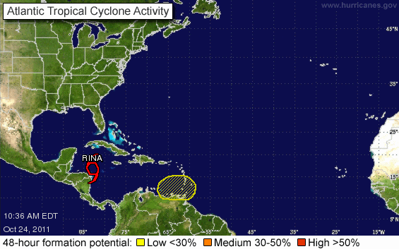
A broad area of low pressure is located several hundred miles east of the southern Windward Islands. There are no signs of organization, and development is unlikely. This system has a low chance, 10 percent, of becoming a tropical cyclone during the next 48 hours as it moves slowly toward the west-northwest.

Image

User avatar
xtech
punchin NOS
Posts: 3004
Joined: March 15th, 2006, 2:01 pm
Contact:

Re: The official tropical weather thread: image updates on p

Postby xtech » October 24th, 2011, 10:07 am

somebody teleport the bad weather?

User avatar
Habit7
TriniTuner 24-7
Posts: 12156
Joined: April 20th, 2009, 10:20 pm

Re: The official tropical weather thread: image updates on p

Postby Habit7 » October 24th, 2011, 10:10 am

this thing like it jump over Trinidad and heading up the road

User avatar
Hook
3NE 2NR Moderator
Posts: 13225
Joined: January 18th, 2004, 9:55 am
Location: The 6%.

Re: The official tropical weather thread: image updates on p

Postby Hook » October 24th, 2011, 10:11 am

no closed isobar, no care

Cid
Riding on 17's
Posts: 1473
Joined: April 8th, 2005, 1:13 pm
Location: Voooosh----------ah in front yu now !!

Re: The official tropical weather thread: image updates on p

Postby Cid » October 24th, 2011, 10:11 am

great job on de info duane....

User avatar
X_Factor
TriniTuner 24-7
Posts: 9581
Joined: April 27th, 2003, 5:54 pm
Location: St. Augustine
Contact:

Re: The official tropical weather thread: image updates on p

Postby X_Factor » October 24th, 2011, 11:41 am

Habit7 wrote:this thing like it jump over Trinidad and heading up the road


hahahaha....for real!....

User avatar
streetbeastINC.
punchin NOS
Posts: 3607
Joined: April 17th, 2003, 11:48 pm
Contact:

Re: The official tropical weather thread: image updates on p

Postby streetbeastINC. » October 24th, 2011, 11:51 am

If you looked at the java anim . it looked like a wind blew from trini and blew the system into
nothingness , was amazing if u into weather patterns..

User avatar
streetbeastINC.
punchin NOS
Posts: 3607
Joined: April 17th, 2003, 11:48 pm
Contact:

Re: The official tropical weather thread: image updates on p

Postby streetbeastINC. » October 24th, 2011, 11:54 am

is the system from the nw heading east???

User avatar
streetbeastINC.
punchin NOS
Posts: 3607
Joined: April 17th, 2003, 11:48 pm
Contact:

Re: The official tropical weather thread: image updates on p

Postby streetbeastINC. » October 24th, 2011, 11:58 am

Image

User avatar
X_Factor
TriniTuner 24-7
Posts: 9581
Joined: April 27th, 2003, 5:54 pm
Location: St. Augustine
Contact:

Re: The official tropical weather thread: image updates on p

Postby X_Factor » October 24th, 2011, 12:13 pm

streetbeastINC. wrote:is the system from the nw heading east???


is that possible?

User avatar
streetbeastINC.
punchin NOS
Posts: 3607
Joined: April 17th, 2003, 11:48 pm
Contact:

Re: The official tropical weather thread: image updates on p

Postby streetbeastINC. » October 24th, 2011, 12:31 pm

^ yup saw it happened a few times....from guyuana to here

User avatar
MG Man
2NRholic
Posts: 23909
Joined: May 1st, 2003, 1:31 pm
Location: between cinco leg

Re: The official tropical weather thread: image updates on p

Postby MG Man » October 24th, 2011, 1:26 pm

heavy downpour / rollin thunder in COuva as of now (1:25pm)

User avatar
White CZ4A
30 pounds of Boost
Posts: 2622
Joined: April 18th, 2003, 2:08 pm

Re: The official tropical weather thread: image updates on p

Postby White CZ4A » October 24th, 2011, 1:32 pm

'storming' in chase vlg at the moment.

User avatar
DSM_05
Riding on 16's
Posts: 1119
Joined: June 23rd, 2007, 6:23 pm

Re: The official tropical weather thread: image updates on p

Postby DSM_05 » October 24th, 2011, 1:59 pm

yep. potential highway flooding?

Rain in Caroni..... like whoa :shock:

User avatar
TRAE
punchin NOS
Posts: 4390
Joined: December 15th, 2008, 2:47 pm
Location: South!
Contact:

Re: The official tropical weather thread: image updates on p

Postby TRAE » October 24th, 2011, 2:01 pm

Heavy flapping rains in st. augustine... anyone going south link with meh for the ride instead of travelling

User avatar
X_Factor
TriniTuner 24-7
Posts: 9581
Joined: April 27th, 2003, 5:54 pm
Location: St. Augustine
Contact:

Re: The official tropical weather thread: image updates on p

Postby X_Factor » October 24th, 2011, 2:04 pm

yupp, epic fackin rain in st augustine (uwi)!!
its really comin from the west!!

User avatar
mansing_12
3NE 2NR for life
Posts: 187
Joined: January 26th, 2007, 12:33 pm
Location: next door
Contact:

Re: The official tropical weather thread: image updates on p

Postby mansing_12 » October 24th, 2011, 2:06 pm

real rain in san juan..... place like night !!!!

User avatar
Habit7
TriniTuner 24-7
Posts: 12156
Joined: April 20th, 2009, 10:20 pm

Re: The official tropical weather thread: image updates on p

Postby Habit7 » October 24th, 2011, 2:07 pm

street lights on...

tiger balm
Sweet on this forum
Posts: 310
Joined: August 9th, 2010, 10:55 pm

Re: The official tropical weather thread: image updates on p

Postby tiger balm » October 24th, 2011, 2:09 pm

Dark clouds coming in from the east over POS. Place getting dark. Hearing some thunder too.

User avatar
X_Factor
TriniTuner 24-7
Posts: 9581
Joined: April 27th, 2003, 5:54 pm
Location: St. Augustine
Contact:

Re: The official tropical weather thread: image updates on p

Postby X_Factor » October 24th, 2011, 2:12 pm

if that piece of cloud really make ah tac back from the West...we gonna be in some trouble

if yuh working in POS i suggest try to leave there now!

Advertisement

Return to “Ole talk and more Ole talk”

Who is online

Users browsing this forum: Chimera and 37 guests